Introduction
Scientists require spatially explicit forest aboveground biomass (AGB) density estimates to quantify the carbon emissions due to deforestation and forest degradation. An accurate estimation of forest AGB is also critical to supporting climate change mitigation and adaptation programs. Traditionally, forest researchers use forest inventory and destructive biomass sampling approaches to estimate forest AGB. In addition, remote sensing scientists use terrestrial laser scanning (TLS) and airborne laser scanning (ALS) to estimate forest AGB. These methods provide essential forest measurements to estimate AGB. However, the methods are costly and time-consuming, limiting spatial and temporal scalability over large forest areas. As a result, forest AGB is poorly quantified in most parts of the world.
Earth observation (EO) technology allows for large-scale assessments of forest ecosystems. Forest researchers and remote sensing scientists can cost-effectively employ forest inventory and EO data acquired from optical, radar, and spaceborne LiDAR systems to estimate AGB. Recently, remote sensing scientists have used NASA’s Global Ecosystem Dynamics Investigation (GEDI) to produce global forest AGB density maps. GEDI is a high-resolution LiDAR system that measures ecosystem structure. Since April 2019, the GEDI spaceborne LiDAR system on the International Space Station (ISS) has collected data on forest ecosystem structure. GEDI provides products at different levels, including ground elevation, canopy top height, canopy cover fraction, leaf area index (LAI), and AGB density.
GEDI Datasets in Earth Engine
National forestry agencies in most tropical countries face technical, financial, and human resource challenges in producing national forest AGB density maps. However, these agencies can use EO data such as GEDI and cloud computing platforms such as Google Earth Engine to create their maps. Early this year, the GEDI team included GEDI’s Level 2A Geolocated Elevation and Height Metrics Product (GEDI02_A) dataset into the Google Earth Engine catalog. The good news is that the GEDI team had the GEDI L4B product into the Google Earth Engine catalog this week.
The GEDI L4B product provides 1 km x 1 km estimates of mean AGB density. In addition, the GEDI L4B product also includes details of the uncertainty of the AGB density estimates. Therefore, this data product shows the relative accuracy and confidence of the average AGB density estimates for each 1-kilometer. The global GEDI L4B product is critical to understanding forest ecosystems and AGB density estimates in poorly quantified areas in the tropics. However, the global GEDI L4B product still has some gaps and uncertainty. Therefore, researchers must do more studies at the local and national levels to reduce the uncertainty of AGB density estimates. In particular, researchers should continue with forest inventories to collect data on forest ecosystem attributes.
Modeling Forest Canopy Height
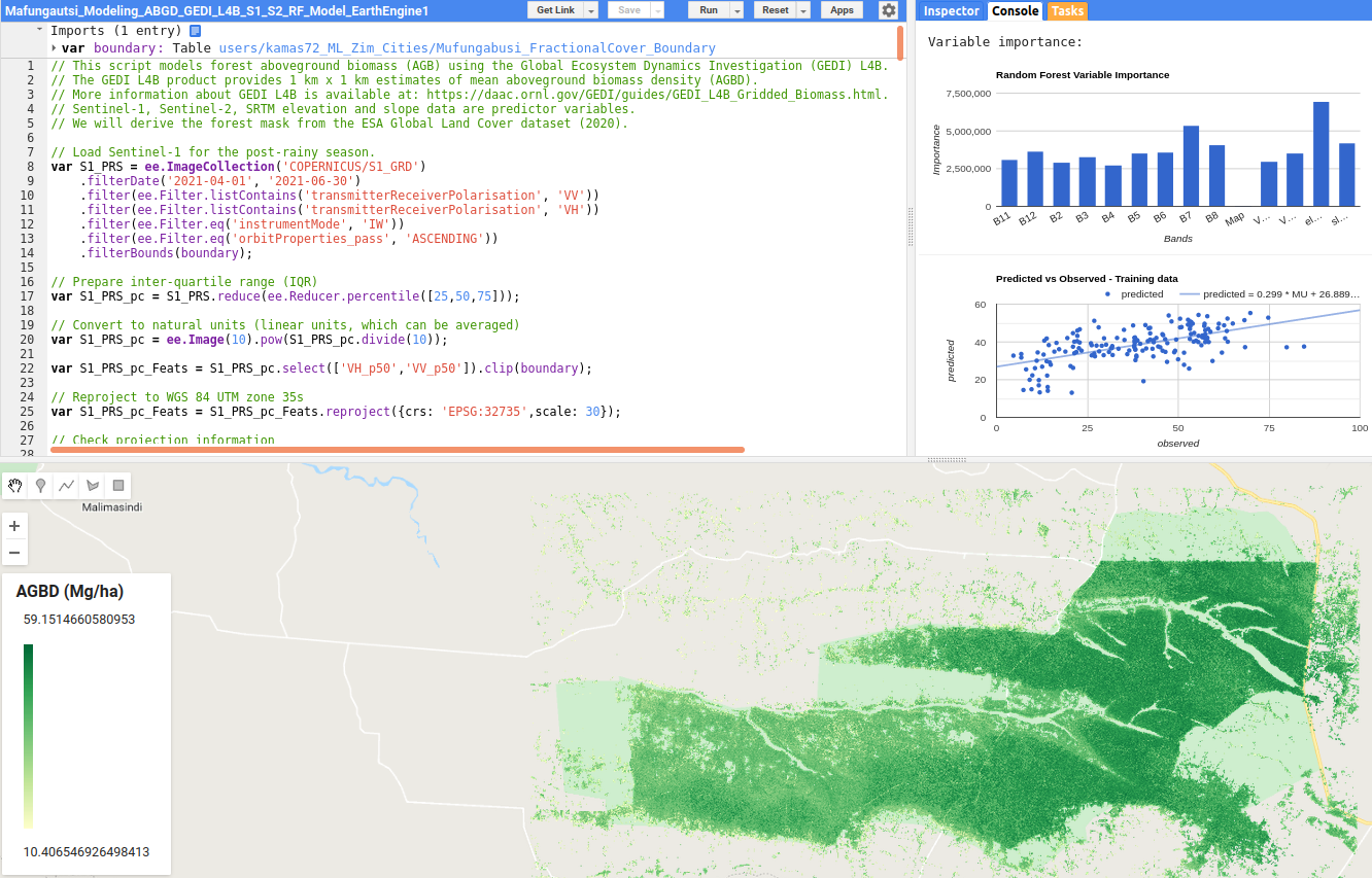
This blog tutorial will model AGB density using the GEDI L4B product available in Google Earth Engine (GEE). We will also use seasonal Sentinel-1 and Sentinel-2 data and elevation data as predictor variables in the RF model.
Next Steps
We will use Mafungautsi Forest Reserve in Zimbabwe as a test site in this post. Readers can access the tutorial and GEE script at Ai.Geolabs.