Introduction
Natural hazards such as cyclones, floods, and droughts have become more intense and frequent in Africa during the past decades. According to the United Nations, the region has experienced major recurrent destructive cyclones, floods, and droughts that affected the livelihoods of many people. In March 2019, cyclones Idai and Kenneth devastated Southern Africa, causing many deaths in Mozambique, Zimbabwe, and Malawi. Furthermore, the cyclones destroyed infrastructure and houses, leaving many people needing basic supplies like food and water. Early this year (January and February), tropical cyclones Ana and Batsirai ravaged Madagascar, Mozambique, and Malawi, causing significant loss of life and destruction.
Knowledge of the spatial extent of flooding is essential for government departments and disaster relief agencies to provide emergency support to the affected people and regions. Government departments and disaster relief agencies require real-time or near-real-time flood extent information to save lives and minimize losses. International organizations such as the United Nations Institute for Training and Research (UNITAR), the Operational Satellite Applications Programme (UNOSAT), and Red Cross have provided critical flood information through their rapid mapping service.
Earth Observation (EO) Data and Cloud Computing for Flood Extent Mapping
International disaster relief agencies have been increasingly using remotely-sensed Earth observation (EO) data to provide flood extent maps in near-real-time. The availability of new EO satellites with improved spatial and temporal coverage and significant advances in cloud computing have improved flood extent mapping. For example, synthetic aperture radar (SAR) data is helpful for flood extent mapping because the SAR signals can penetrate through the clouds. The all-weather capability of the SAR satellite is critical for flood mapping during heavy rainfall.
To date, international disaster relief agencies, space agencies, and companies produce flood maps for disaster recovery and response using EO data and cloud computing. However, government departments and local authorities still lack the capacity to map floods in most African countries. One of the challenges that the government disaster departments and local authorities face is the unavailability of current pre-flood base maps to use as a basis for comparison with the post-flood scenario to assess the loss caused by the devastating cyclone accurately. In addition, flood mapping is often ad-hoc and limited to single events, making it difficult for decision-makers to manage disasters and plan for future events. Therefore, government disaster departments and local authorities need previous flood extent and frequency information to have a basis for informed decision-making in planning and managing flood-affected communities.
Next Steps
The United Nations Platform for Space-based Information for Disaster Management and Emergency Response (UN-SPIDER) provides a platform to develop the capacity to use EO data for disaster management. UN-SPIDER prioritizes access and use of EO and cloud-computing technologies during all phases of the disaster management cycle. Therefore, government departments and local authorities need training to map and model floods using these technologies. In addition, the increasing frequency and intensity of tropical cyclones and flooding require a regional initiative to manage and mitigate risk in Africa.
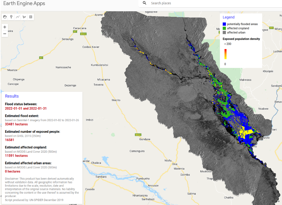
This blog post will use the UN-SPIDER tutorial, Sentinel 1 data, and Google Earth Engine (GEE) to map the recent flood extent (after tropical cyclone Ana) in Chikwawa district in Malawi. Readers can access the GEE app and script below.