Introduction
Forest ecosystems offer critical ecosystem services, such as providing food and materials, protecting watersheds, and regulating local climate. Scientists note that forests nurture essential biodiversity that underpins many ecosystem functions. However, forests are increasingly threatened by human activities. The international community has proposed various global initiatives to monitor, manage and conserve forest ecosystems. During the past decade, the Food and Agriculture Organization of the United Nations (FAO) has been helping countries to develop National Forest Monitoring Systems (NFMS). The NFMS depends on the National Forest Inventories (NFIs), which provide various forest resource information.
National forestry agencies use NFI programs to develop sustainable policies and management strategies. The national forestry agencies are mandated to produce timely and accurate estimates on forests through the NFI programs. The aim is to periodically report the current state of forests and changes in forests for monitoring and accounting purposes. National forestry agencies provide quantitative statistical information on the area, species composition, volume, and growing stock for FAO’s Global Forest Resources Assessments reports. However, national forestry agencies in most low-income countries face challenges in producing and updating national forest resource information, given the high cost of conducting field-based national inventories and creating maps.
Rapid Wall-to-Wall Forest Cover Mapping
Remote sensing experts have demonstrated the effectiveness of EO data and machine learning methods in producing land cover information. To date, various global land cover map products derived from MODIS, Landsat, and Sentinel data are available. While these global map products are a valuable resource for global change studies, they do not account for national forest cover definitions. As a result, most national forest agencies do not find them useful for their national projects.
During the past decades, most national forestry agencies have been using Earth observation (EO) technologies to produce forest cover information for their NFI programs. However, a lack of financial and technical capacity, among other factors, limits national forestry agencies from creating reliable forest cover information consistently and timely. For example, it takes a long time to compile training areas used for forest cover mapping. Therefore, a simple and reproducible approach is required to collect training data.
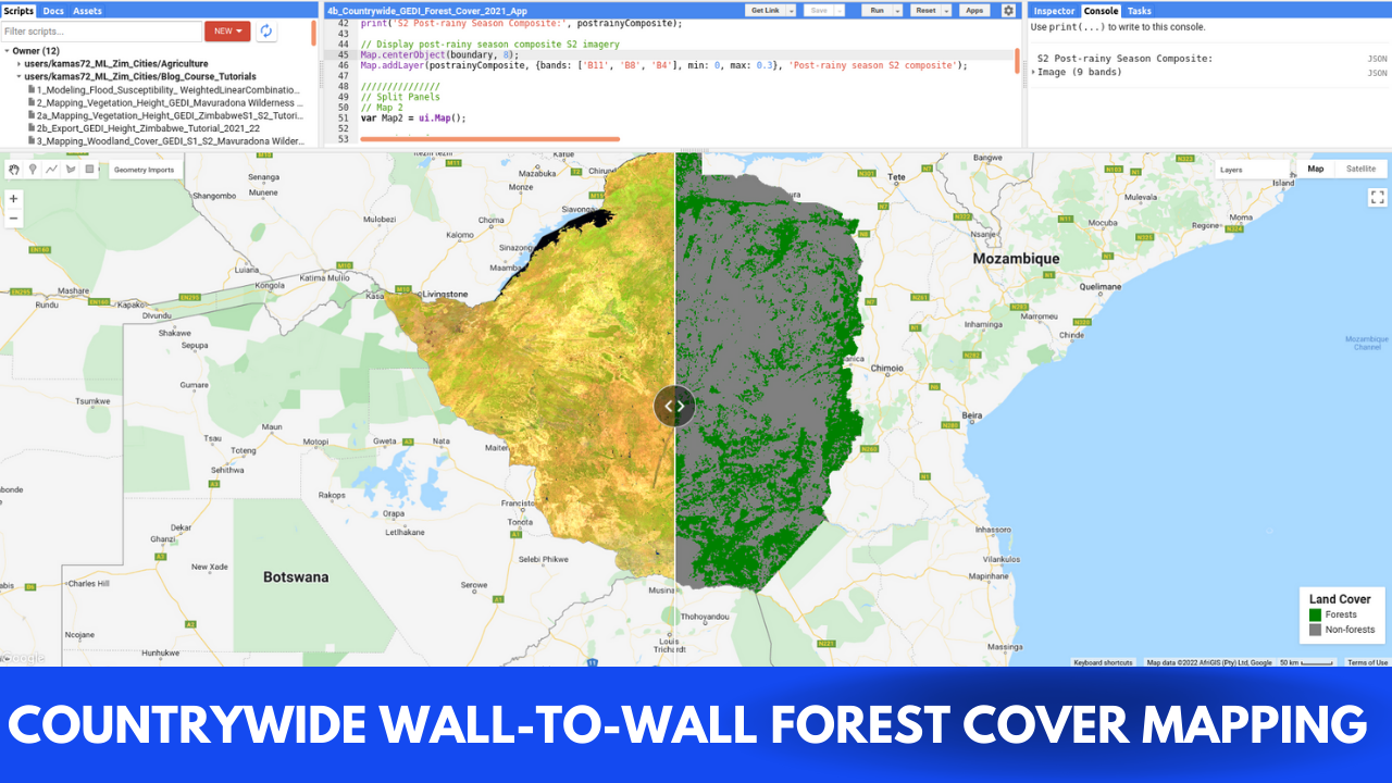
National forestry agencies can use a training data automation approach that uses satellite-based LiDAR systems and national forest cover definition. For example, remote sensing analysts can derive height metrics from the Global Ecosystem Dynamics Investigation (GEDI) data and stratify them into forest and non-forest classes. An independent team can check the forest and non-forest training data to remove discrepancies. Then finally, remote sensing analysts can use the training data for forest cover mapping. This training data automation approach is faster, reliable, and reproducible, allowing for the update of forest cover information cost-effectively.
Next Steps
This blog tutorial will map countrywide forest cover using training data derived from GEDI’s Level 2A (100 relative height metrics). We will also use Sentinel-1, Sentinel-2, and elevation data as predictor variables in the random forest (RF) model. The blog tutorial uses the Zimbabwe Forestry Commission’s definition of forest and woodlands. The Forestry Commission defines natural moist forest as land with moist evergreen and deciduous species with a canopy cover above 80% and a tree height of more than 15 m. Woodland includes open to dense areas with a canopy cover of between 20% and 80% and tree height between 5 m and 15 m. Readers can access the tutorial and GEE script at AI.Geolabs.