Introduction
Woodland cover maps are critical for understanding spatial and temporal patterns of biodiversity. Natural resource managers require timely and up-to-date woodland cover information to formulate and implement sustainable biodiversity planning and management. To date, woodland cover information is sparse or lacking in most low-income countries, given the high cost of producing maps. Conventional woodland cover mapping methods such as field surveys and interpretation of aerial photographs are labor-intensive and costly. However, Earth observation (EO) technology based on remote sensing (low and medium spatial resolution) offers cost-effective ways to map woodland cover in vast areas.
Woodland Cover Mapping: The Challenges
Remote sensing experts have made significant progress in land cover mapping during the past decades, especially in high-income countries. For example, remote sensing experts have used machine learning methods and satellite EO data to map land cover on a large scale. However, mapping woodland cover types remains a challenge in heterogeneous landscapes such as the Miombo ecosystem due to several environmental and anthropogenic factors. First, vegetation exhibits high spatial heterogeneity (e.g., vegetation forms and types, tree density and size), influenced by soil type, topography, fire, herbivores, and land management practices. The complex vegetation forms (characterized by closed and open woodlands, bushland, and grasslands), spatial heterogeneity, and low inter-class separability lead to similar spectral responses at Landsat or Sentinel imagery resolution.
Second, seasonal changes significantly influence woodland cover. Spectral reflectance patterns of the woodland cover vary according to water availability during the short rainy season and long dry season. Therefore, it is challenging to discriminate between woodlands (closed or open) and bushland (dense or scattered). Researchers have used multi-seasonal satellite imagery and multiple EO datasets to improve woodland cover mapping in the Miombo ecosystem. However, challenges remain because accurate woodland cover mapping is limited to regions where reliable field data exists. As a result, woodland cover mapping is poor in places where field data is scarce.
GEDI for Woodland Cover Mapping
Remote sensing experts have applied many methods to improve land cover mapping in regions where field data is scarce. For example, researchers have developed machine learning models that need fewer training data or used dense satellite time series to map land cover. Researchers have also used crowdsourced training data instead of field survey data in some cases. While these approaches have improved accuracy, the land cover classification models remain local. Applying these models to other places sees a rapid decline in model performance and increased misclassifications.
There is a greater need to develop reliable models that use small training datasets. Remote sensing experts can use multi-seasonal EO data (e.g., Landsat and Sentinel) to create semi-automatic machine learning models that use space-borne LiDAR height metrics as training data. For example, height metrics derived from the global ecosystem dynamics investigation (GEDI) data can stratify woodland cover into different types. Stratifying woodland cover types based on height metrics takes advantage of existing national land cover classification schemes that use height, thus leading to greater acceptance by national forestry agencies. Although remote sensing experts still need field survey data for accuracy assessment, GEDI height metrics can bridge the existing data gaps and improve the quality of woodland cover maps.
Next Steps
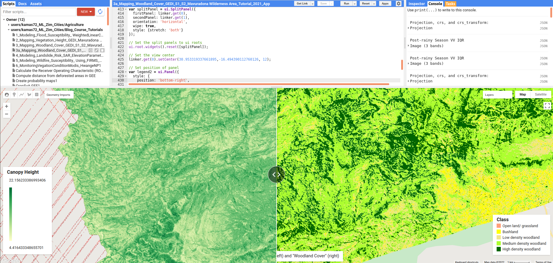
This blog tutorial will map woodland cover using GEDI’s Level 2A (100 relative height (RH) metrics). We will also use Sentinel-1, Sentinel-2, and elevation data as predictor variables in the random forest (RF) model. In this post, we will use Mavuradona Wilderness Area in Zimbabwe as a test site. Readers can access the tutorial and GEE script at AI.Geolabs, and also the App here.