Introduction
Vegetation is essential in the global terrestrial ecosystem since it provides ecosystem services such as protecting the land surface, modifying the local climate, and conserving biodiversity. The structure of vegetation substantially influences ecosystem function and productivity. Scientists report that vegetation structure correlates with biophysical parameters such as aboveground biomass (AGB) and primary productivity. Therefore, detailed quantification of vegetation structure is crucial for assessing the structure and functioning of ecosystems.
Detailed spatial information on vegetation structure, such as height, is critical for land management and planning for nature conservation, fire risk management, and greenhouse gas emissions mitigation. Traditionally, researchers used direct field measurements to collect vegetation structure parameters. However, obtaining vegetation structural parameters in the field is labor-intensive, time-consuming, and expensive. In addition, field measurements are limited in spatial extent, typically to a few test sites. Therefore, researchers can use remote sensing methods to develop quantitative and standardized indicators of vegetation structure over broad spatial areas.
Space-borne LiDAR for Vegetation Height Mapping
Earth observation systems such as Light Detection and Ranging (LiDAR) have the potential to estimate vegetation structural parameters. However, existing ground and airborne LiDAR sensors have limited spatial coverage and a relatively high acquisition cost, suitable for small local projects. Space-borne LiDAR systems such as GEDI provide a global and broader spatial range. Although the GEDI measurements are sparse in both space and time, they provide critical information on vegetation structure in temperate and tropical regions.
Mapping Vegetation Height
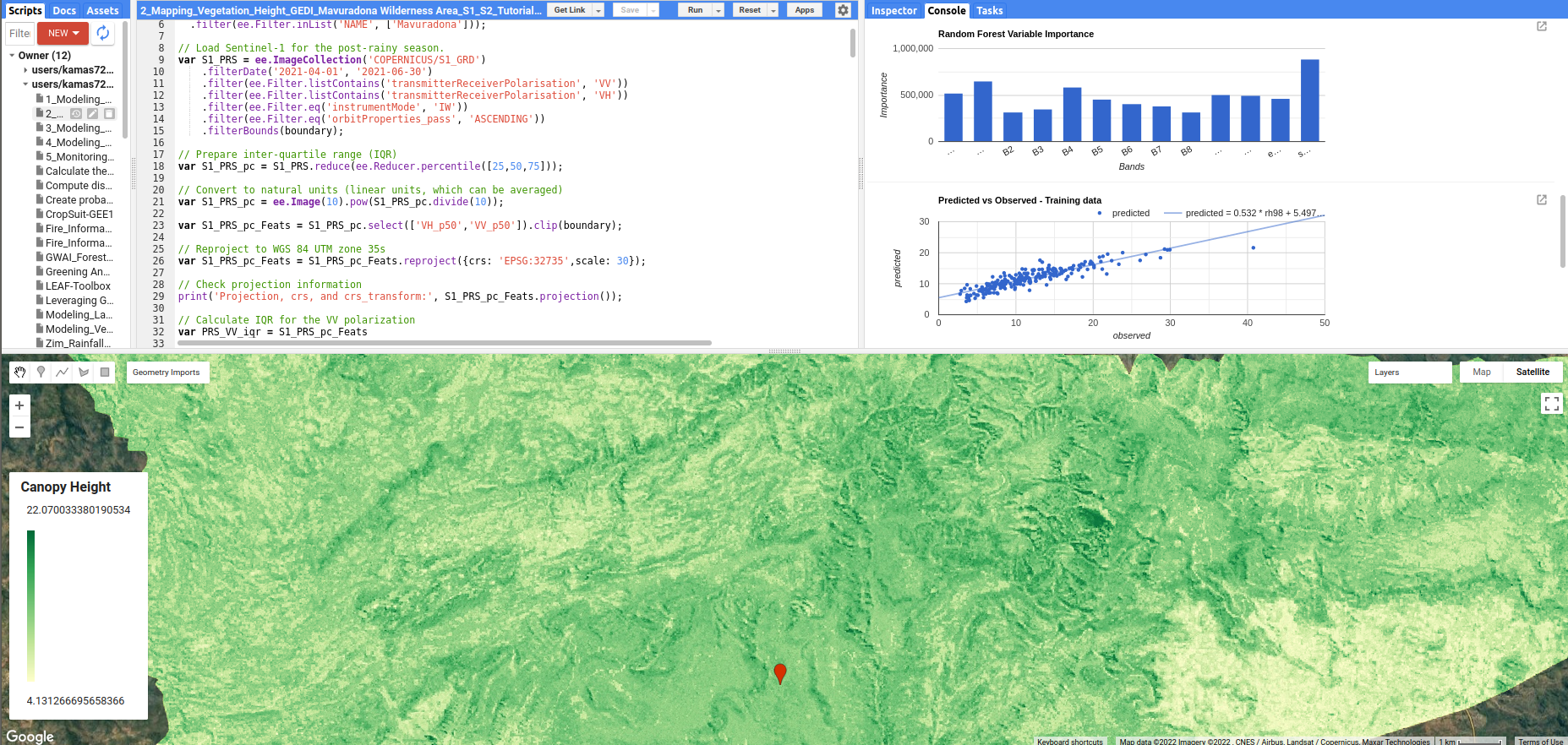
This blog tutorial will map vegetation height using GEDI’s Level 2A Geolocated Elevation and Height Metrics Product (GEDI02_A). The “GEDI02_A” dataset comprises 100 Relative Height (RH) metrics. We will also use Sentinel-1, Sentinel-2, and elevation data as predictor variables in the RF model.
Next Steps
In this post, we will use Mavuradona Wilderness Area in Zimbabwe as a test site. Readers can access the tutorial and GEE script at Ai.Geolabs.